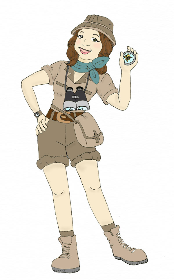
"Using our compass to guide us along, let us travel together around the world. There are places to discover and people to meet. Let’s make new friends in all directions."Compass RosieWhen Compass Rosie was young, she would always dream of traveling around the world. She read many travel and geography books on places and people. Then, she would use her imagination to pretend that she was there meeting the people and exploring the sites. Then when she got older, she decided to not only read about the places and people, but see and experience them for herself. Now you can read about her travels throughout the world. She always has her compass with her and uses it on her journeys. She wants her readers to see and learn about the places she has been in hopes that someday they will be able to travel and see them too! Compass Rosie hopes to stimulate their interest to travel. She believes that in traveling to new places, you have the opportunity to meet people in their country and hopefully gain a better appreciation and understanding of them. Read about her first trip....Machu Picchu, Peru
Compass Rosie Prepares for her TripCompass Rosie took out her backpack and put it on the table. She was excited about her upcoming trip to Machu Picchu, Peru.Let’s see, where did I put my notebook, she thought. There it is! She picked it up and started to turn the pages until she came to her checklist. Compass Rosie kept a notebook of her trips. She always liked to research the area she was traveling to and kept notes on helpful information. She opened up the first page where she had written in large letters Machu Picchu, Peru. She turned the page and looked at her checklist of things she will need for the trip. She read off the list that included compass, camera, binoculars, sunscreen, hat, maps, clothes and the list went on. It had to all fit into her backpack because she was going to be hiking The Inca Trail to Machu Picchu. “Machu Picchu means old mountain or peak,” she read aloud. Compass Rosie picked up her world map and found South America. She looked on the west coast of South America for the country, Peru. She looked closely at the map and traced her journey. She was going to fly 14 hours to Lima, Peru, which is the capital of Peru. Next, she would fly from Lima to Cuzco, Peru. Her guide, Luis, was going to pick her up at the airport. After spending a day in Cuzco, they would travel to where The Inca Trail to Machu Picchu would begin. Arriving in CuzcoShe stepped out of the plane and immediately noticed the difference in altitude. Cuzco is at 11,000 feet above sea level. It is actually 3,000 feet taller than Machu Picchu, which is at about 7,970 ft. She noticed that it felt a little harder to breathe and any exertion made her feel very tired. Compass Rosie knew that to counter the effects of high altitude she needed to drink a lot of fluids and take it easy the first day. If she did that, then she would begin to get used to the higher altitude.Luis was holding a large sign that read, Compass Rosie. She waved to Luis and said, “ˇHola!, Yo soy la Compass Rosie.” (Hello, I am Compass Rosie.) She knew that about 84% of the Peruvians spoke Spanish. Also, Quechua, the language of the Inca Empire is an official language of both Peru and Bolivia. It is widely spoken in different dialects throughout South America. It is called simi rama, which means language of the people.
As they traveled to their first stop, she opened up her notebook and asked her guide to help her say some of the Quechua words.
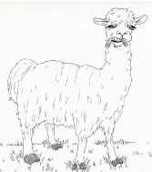
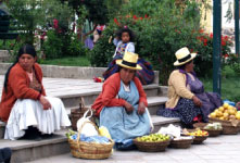
Luis said, “I believe you already know one Quechua word before you came here.” “Really,” she said excitedly. “Yes, what do you call that animal?” he said as he pointed to an animal that was grazing on the grass. Quickly she said, “That is a llama.” As she said that the llama stopped grazing and looked up at her with a mouthful of grass. Compass Rosie and Luis laughed at the funny site of the llama. Compass Rosie quickly got out her camera and took a photo of him. Compass Rosie Meets two Peruvian Children Luis and Compass Rosie boarded a bus in Cuzco and travelled for a couple of hours to the city of Ollantaytambo. They were going to stay overnight there before beginning their hike. Compass Rosie took a photo of ladies selling fresh produce. Luis and Compass Rosie boarded a bus in Cuzco and travelled for a couple of hours to the city of Ollantaytambo. They were going to stay overnight there before beginning their hike. Compass Rosie took a photo of ladies selling fresh produce.
As she looked around, Compass Rosie saw two young girls carrying a baby llama in their bag. They were so cute. She smiled at them, walked up, and patted the llama on the head. The children were surprised when she said in Quechua, “Rimaykullayki.” It means hello. The children smiled and said in English to her, “Hello.” The girls’ skirts, vests, and hats were brightly colored. The girls were very curious and wanted to know more about Compass Rosie. Luckily, Luis was nearby and he started translating back and forth between the girls and Compass Rosie. The older girl’s name was Alessandra and the younger girl’s name was Angelica. When she told them her name the younger girl said their mother’s name is Rosa. The girls offered to be Compass Rosie’s special guides. Compass Rosie and Luis walked around Ollantaytambo with the girls.
The girls pointed to one basket and said, “Papa.” Compass Rosie looked into the basket and saw many different sizes and colors of potatoes. They were purple, yellow, red, and some even looked black. Potatoes had been domesticated in the High Andes of southeastern Peru over 10,000 years ago. The papa became an important food for the early Peruvian culture. Alessandra picked an ear of corn that was black and said, “Maiz Morado.” Compass Rosie noticed the kernels of corn were a lot larger than the ones found in the United States and Europe. Luis told her that there are about 35 different varieties of corn in Peru. One variety is called Choclo and it is a variety that had been cultivated in ancient times in Peru. As they walked around they saw ladies sitting on the ground weaving. They had a loom made of tree branches. They were laughing and talking as they sat weaving. The designs were beautiful and Compass Rosie was impressed with the difficult designs they were weaving. Luis told her that before the ladies begin to weave they have to shear the animals and wash the fibers. Then, the fibers are spun into a fine yarn. As the spindle twists the fibers together it forms yarn. The weaver has to control the thickness of the yarn. If the yarn is not even, it will not weave properly. The yarn is dyed using plants and minerals to achieve the rich colors.
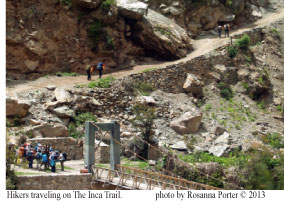
The Hike to Machu PicchuAfter breakfast, Compass Rosie and Luis began their hike.Luis said, “Machu Picchu was built by the Incas in the 15th century, which was at the height of their Empire. Some people refer to it as the Lost City of the Incas. It was said to have been built for the rulers Pachacutec and Tupac Inca Yupanqui. “What happened to the Incas that were here?” asked Compass Rosie. “Some believe they got smallpox from travelers in Cuzco, which spread to Machu Picchu. In about 100 years the site was abandoned. It is believed the Spanish conquistadors never arrived here,” answered Luis. Before she left, she opened up her journal and began to keep track of her journey to Machu Picchu. At each stop, she jotted down notes of what she saw. The following are her journal entries from her hike.
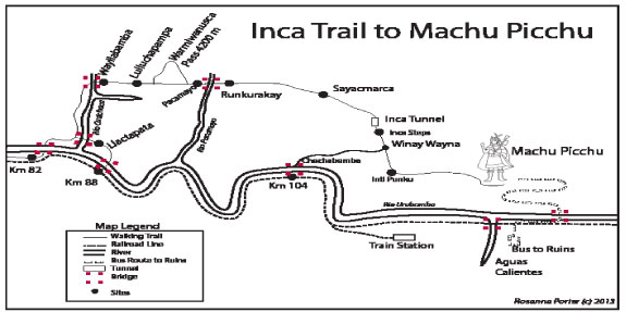
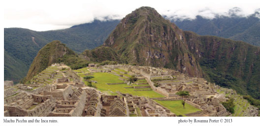
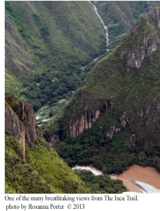
We crossed over the fast flowing Urubamba River. The first Inca ruins we passed were of Llactapata, which means town on a hillside in Quechua. The hike has been fairly easy, but Luis said this was the easiest day of our hike. We camped our first night in Wayllabamba the only inhabited village on our four day trek. The cities and ruins are very interesting. Today, we hiked about 7 miles. Day 2: Today, we hiked about 6.5 miles. It was a very steep incline of about 3,940 feet in elevation. We saw spectacular views when we reached Dead Woman’s Pass and that is just how I felt. It was named because of the outline of a woman that is created by the mountain ridges. And, what goes up must go down. We began our descent to our next campsite at Pacamayo. I was exhausted and glad the hardest part of the hike was over! Day 3: We continued downhill today and walked about 10 miles. The area is a subtropical cloud forest. It is where the Amazon basin begins. A cloud forest is also called a fog forest. The fog or cloud hangs over the area over a long period and can be seasonal. The clouds are at the level of the tops of the trees. It seemed a little eerie. We passed Runkurakay a storage depot for the Incas when they were taking supplies back and forth from Machu Picchu and Cuzco. We passed Sayacmarca, which could have been used by early travelers. We stopped at the ruins of Phuyupatamarca and they are considered the best restored ruins on the hike. It is also where we got our first glimpse of the back side of Machu Picchu. Wińay Wayna was our final night’s stop. Day 4: The last day of the hike was less than 4 miles. We woke up before sunrise so that we could reach Machu Picchu in time to watch the sunrise over it. We passed by Inti Punku, the Sun Gate. I sat in wonder at the magnificent site of Machu Picchu. It was amazing to see what the Inca civilization was able to build. I took many pictures of the ruins. I also remembered to get my passport stamped at the entrance into Machu Picchu. Compass Rosie’s trip was coming to an end. She took the bus back down to Aguas Calientes, where she spent the night before taking the train and bus back to Cuzco. This was an incredible trip! Look at the map below and trace Compass Rosie's path on the Inca Trail to Machu Picchu.
|
 Day 1: After breakfast, we hiked from Ollantaytambo to marker km 82 and began our four day hike to Machu Picchu.